鼎鸿锐源工程机械有限公司

欢迎来到鼎鸿锐源工程机械有限公司官网!

GX空防科技

​Introducing the Revolutionary GX101B VTOL Fixed-Wing Drone

Introducing the Revolutionary GX101B VTOL Fixed-Wing DroneThe GX101B Vertical Take-Off and Landing (VTOL) Fixed-Wing Drone is a cutting-edge unmanned aerial vehicle designed for stable monitoring and

浏览:

微信:15052009878 WhatsApp me

详情

Introducing the Revolutionary GX101B VTOL Fixed-Wing Drone

The GX101B Vertical Take-Off and Landing (VTOL) Fixed-Wing Drone is a cutting-edge unmanned aerial vehicle designed for stable monitoring and recording in diverse scenarios. This comprehensive system, consisting of the drone platform, mission payload, wireless link, and ground station, ensures reliable real-time transmission of location information, flight data, and captured video back to the ground station or command center.
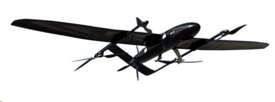
GX101B 垂直起降固定翼无人机

Key Features and Technical Specifications

  • Power System: Pure Electric

  • Maximum Take-Off Weight: 17Kg

  • Wingspan: 3.0m

  • Fuselage Length: 1.8m

  • Maximum Payload Capacity: 3Kg

  • Maximum Endurance: 360 minutes

  • Maximum Flight Altitude: 7000m

  • Control Method: Fully Autonomous VTOL

  • Wind Resistance: Level 6 (Vertical Take-Off); Level 8 (Cruise)

  • Operating Temperature: -20℃ to 50℃

  • Control Link: Integrated Data and Video Link up to 50KM

  • Electro-Optical Gimbal: Dual-Light Spherical Electro-Optical Gimbal

  • Ground Station: High-Performance HP Computer

Product Uses and Applications

The GX101B VTOL drone is a versatile platform suitable for a wide range of applications, including:

  • Security and Surveillance: Ideal for border patrol, infrastructure inspection, and event monitoring, providing real-time video and data.

  • Search and Rescue: Long endurance and high flight altitude capabilities make it perfect for locating individuals in remote or hazardous environments.

  • Mapping and Surveying: Equipped with appropriate payloads, it can perform high-precision aerial mapping and surveying tasks.

  • Agricultural Monitoring: Monitor crop health, irrigation, and livestock over large areas.

  • Environmental Monitoring: Track wildlife, monitor pollution levels, and assess environmental changes.

  • Disaster Response: Provide critical situational awareness and aid in damage assessment during natural disasters.

Advantages and Selling Points

  • Extended Endurance: With a remarkable 360-minute maximum flight time, the GX101B can cover vast areas and stay airborne for extended periods.

  • High Operational Altitude: Reach altitudes up to 7000 meters, providing a broad perspective for surveillance and data acquisition.

  • Autonomous Vertical Take-Off and Landing: Enables operation in complex terrains and areas with limited space, eliminating the need for runways.

  • Robust Wind Resistance: Capable of withstanding winds up to Level 6 during vertical take-off and Level 8 during cruise flight, ensuring stable operation in challenging weather conditions.

  • Long-Range Control and Data Link: The integrated 50KM data and video link allows for extensive operational range and real-time data transmission.

  • Advanced Payload Integration: Equipped with a high-performance dual-light spherical electro-optical gimbal for superior video capture and monitoring capabilities.

  • Comprehensive Ground Station: Includes a powerful HP computer for seamless control, data processing, and mission management.

Application Scenarios and Case Studies

The GX101B has proven its effectiveness in various real-world scenarios:

  • Border Security: Successfully deployed for long-duration patrols along extensive borderlines, providing real-time intelligence and reducing illegal activities.

  • Infrastructure Inspection: Used to inspect power lines and pipelines over hundreds of kilometers, identifying potential faults and reducing manual inspection costs.

  • Environmental Research: Played a crucial role in monitoring wildlife populations in remote natural reserves, providing valuable data for conservation efforts.

  • Disaster Relief Operations: Provided aerial reconnaissance after earthquakes and floods, helping rescue teams identify affected areas and plan their response effectively.

Frequently Asked Questions (FAQ)

  1. Q: What is the typical range for controlling the GX101B?
               A: The GX101B features an integrated data and video link with a range of up to 50 kilometers, providing extensive operational coverage.

  2. Q: Can the GX101B operate in cold weather conditions?
               A: Yes, the GX101B is designed to operate in a wide temperature range from -20℃ to 50℃, making it suitable for various environmental conditions.

  3. Q: What kind of payload can be integrated with the GX101B?
               A: The GX101B has a maximum payload capacity of 3Kg and is equipped with a dual-light spherical electro-optical gimbal, which can accommodate various sensors and cameras depending on the mission requirements.

热门产品

详情

Introducing the Revolutionary GX101B VTOL Fixed-Wing Drone

The GX101B Vertical Take-Off and Landing (VTOL) Fixed-Wing Drone is a cutting-edge unmanned aerial vehicle designed for stable monitoring and recording in diverse scenarios. This comprehensive system, consisting of the drone platform, mission payload, wireless link, and ground station, ensures reliable real-time transmission of location information, flight data, and captured video back to the ground station or command center.

GX101B 垂直起降固定翼无人机

Key Features and Technical Specifications

  • Power System: Pure Electric

  • Maximum Take-Off Weight: 17Kg

  • Wingspan: 3.0m

  • Fuselage Length: 1.8m

  • Maximum Payload Capacity: 3Kg

  • Maximum Endurance: 360 minutes

  • Maximum Flight Altitude: 7000m

  • Control Method: Fully Autonomous VTOL

  • Wind Resistance: Level 6 (Vertical Take-Off); Level 8 (Cruise)

  • Operating Temperature: -20℃ to 50℃

  • Control Link: Integrated Data and Video Link up to 50KM

  • Electro-Optical Gimbal: Dual-Light Spherical Electro-Optical Gimbal

  • Ground Station: High-Performance HP Computer

Product Uses and Applications

The GX101B VTOL drone is a versatile platform suitable for a wide range of applications, including:

  • Security and Surveillance: Ideal for border patrol, infrastructure inspection, and event monitoring, providing real-time video and data.

  • Search and Rescue: Long endurance and high flight altitude capabilities make it perfect for locating individuals in remote or hazardous environments.

  • Mapping and Surveying: Equipped with appropriate payloads, it can perform high-precision aerial mapping and surveying tasks.

  • Agricultural Monitoring: Monitor crop health, irrigation, and livestock over large areas.

  • Environmental Monitoring: Track wildlife, monitor pollution levels, and assess environmental changes.

  • Disaster Response: Provide critical situational awareness and aid in damage assessment during natural disasters.

Advantages and Selling Points

  • Extended Endurance: With a remarkable 360-minute maximum flight time, the GX101B can cover vast areas and stay airborne for extended periods.

  • High Operational Altitude: Reach altitudes up to 7000 meters, providing a broad perspective for surveillance and data acquisition.

  • Autonomous Vertical Take-Off and Landing: Enables operation in complex terrains and areas with limited space, eliminating the need for runways.

  • Robust Wind Resistance: Capable of withstanding winds up to Level 6 during vertical take-off and Level 8 during cruise flight, ensuring stable operation in challenging weather conditions.

  • Long-Range Control and Data Link: The integrated 50KM data and video link allows for extensive operational range and real-time data transmission.

  • Advanced Payload Integration: Equipped with a high-performance dual-light spherical electro-optical gimbal for superior video capture and monitoring capabilities.

  • Comprehensive Ground Station: Includes a powerful HP computer for seamless control, data processing, and mission management.

Application Scenarios and Case Studies

The GX101B has proven its effectiveness in various real-world scenarios:

  • Border Security: Successfully deployed for long-duration patrols along extensive borderlines, providing real-time intelligence and reducing illegal activities.

  • Infrastructure Inspection: Used to inspect power lines and pipelines over hundreds of kilometers, identifying potential faults and reducing manual inspection costs.

  • Environmental Research: Played a crucial role in monitoring wildlife populations in remote natural reserves, providing valuable data for conservation efforts.

  • Disaster Relief Operations: Provided aerial reconnaissance after earthquakes and floods, helping rescue teams identify affected areas and plan their response effectively.

Frequently Asked Questions (FAQ)

  1. Q: What is the typical range for controlling the GX101B?
               A: The GX101B features an integrated data and video link with a range of up to 50 kilometers, providing extensive operational coverage.

  2. Q: Can the GX101B operate in cold weather conditions?
               A: Yes, the GX101B is designed to operate in a wide temperature range from -20℃ to 50℃, making it suitable for various environmental conditions.

  3. Q: What kind of payload can be integrated with the GX101B?
               A: The GX101B has a maximum payload capacity of 3Kg and is equipped with a dual-light spherical electro-optical gimbal, which can accommodate various sensors and cameras depending on the mission requirements.

橡胶管101
长按识别二维码查看详情
长按图片保存/分享
询盘

咨询表单:

咨询内容:


你还没有添加任何产品

加入成功
添加微信好友,详细了解产品
https://www.dinghongruiyuan.com/uploadfile/15052009878
使用企业微信
“扫一扫”加入群聊
复制成功
https://www.dinghongruiyuan.com/uploadfile/15052009878
添加微信好友,详细了解产品
我知道了